
Mean Sea Level models
The monthly-to-decadal extremes in local sea level are not understood.

Though very distinct, the sea level variations at a coastal site such as Warnemunde, Germany on the Baltic lack any formal model.
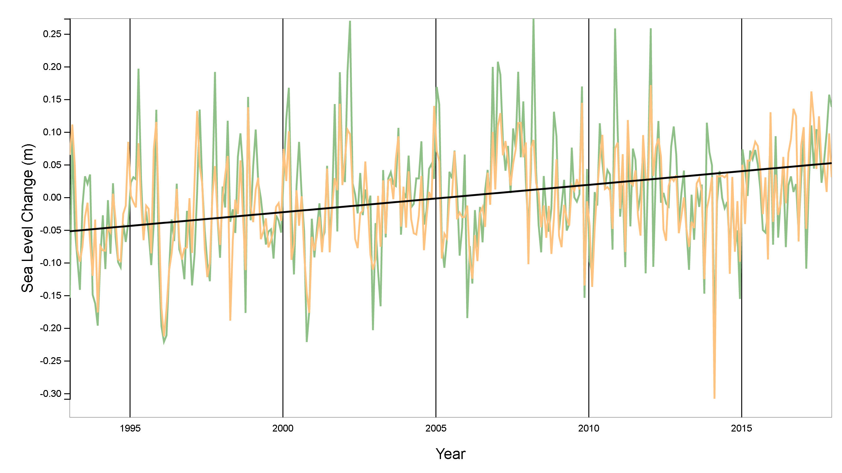
The erratic nature is not measurement error or noise since the classic tidal gauge measurements agree with the satellite-based altimetry measurements, as shown above in a NASA chart. There is also a long-term trend that is of obvious interest from a climate change perspective.
The uncertainty in attribution and inability to model this variability is quite unlike the near machine-level precision of the daily tidal cycles, which are continuously fitted and calibrated by recent data. Everything there is well-understood and modeled by a handful of lunar periods and harmonics of the daily cycle. Yet, these models are continuously updated to account for the longer-term variability.
A tentative attribution of the mean variation is repeated at every coastal site archived by NOAA, for example:
“The average seasonal cycle and linear sea level trend have been removed. Interannual variation is caused by irregular fluctuations in coastal ocean temperatures, salinities, winds, atmospheric pressures, and ocean currents. The interannual variation for many Pacific stations is closely related to the El Niño Southern Oscillation (ENSO)” — at the Kahului, Hawaii site
That’s the best that they can do — assign an attribution to other (potentially confounding) factors and to an equally mysterious behavior such as El Nino.
Yet, it’s more likely that the erratic fluctuations are simply an extension of the conventional tidal forcing mechanisms.
I assert that a local mean sea level (MSL) model can be derived by modulating an annual impulse with long-period lunar tidal forces (fortnightly & monthly) and integrated. In addition, a Laplace’s Tidal Equation modulation is applied1 -- the modulation is increased from a linear factor to a stronger sinusoidal factor.
The lower panel shows how the tidal spectral harmonics change in amplitude depending on the frequency of the modulating sine wave (shown in inset).
This model is repeated for over 130 other MSL coastal sites around the world and cross-validated via training and test intervals here : climate.pukite.com
Derived in: Mathematical GeoEnergy, P.Pukite, D.Coyne, D.Challou, Wiley/AGU, 2019
About the coastal site used for MSL: Warnemünde is a seaside resort and a district of the city of Rostock in Mecklenburg, Germany. It is located on the Baltic Sea and, as the name implies, at the estuary of the river Warnow. Data downloaded from Permanent Service for Mean Sea Level (PSMSL): https://psmsl.org/data/obtaining/rlr.monthly.data/11.rlrdata